

Yellowstone National Park
from $55.00
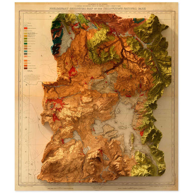
1878 United States Geological Survey geological map of Yellowstone National Park combined with a digitally-rendered 3-dimensional elevation. 2D pr...
View full details
1878 United States Geological Survey geological map of Yellowstone National Park combined with a digitally-rendered 3-dimensional elevation. 2D pr...
View full details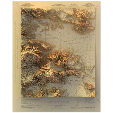
1943 United States Geological Survey topographic map of the Joshua Tree National Park region combined with a digitally-rendered 3-dimensional eleva...
View full details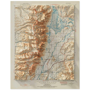
1899 United States Geological Survey topographic map of the Grand Teton National Park region combined with a digitally-rendered 3-dimensional eleva...
View full details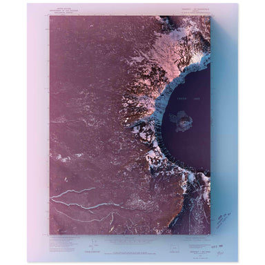
1975 United State Geological Survey topographic map of Crater Lake, Oregon combined with a digitally-rendered 3-dimensional elevation. 2D print Lu...
View full details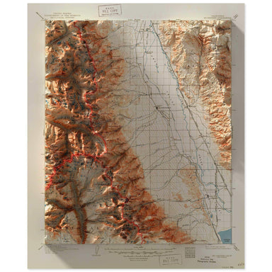
2D print Lustre Prints: Archival photo inkjet print on lustre (slight sheen) paper. Matte Giclée Prints: Archival pigment-based artist's print on ...
View full details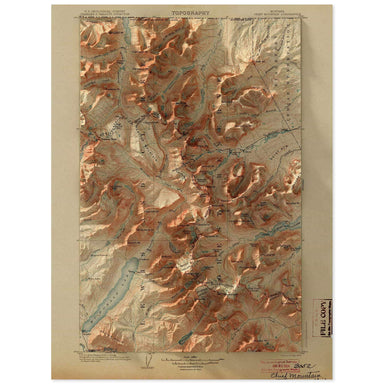
1904 United States Geological Survey topographic map of the Glacier National Park region combined with a digitally-rendered 3-dimensional elevation...
View full details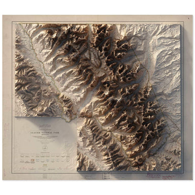
1915 United States Department of the Interior Administrative Map of Glacier National Park Montana combined with a digitally-rendered 3-dimensional ...
View full details
1980 United States Geological Survey topographic map of Zion National Park's Temple of Sinawava, including the famous Narrows hike, combined with a...
View full details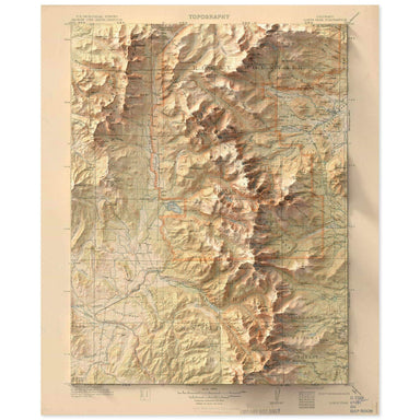
1915 United States Geological Survey topographic map of the Rocky Mountain National Park region combined with a digitally-rendered 3-dimensional el...
View full details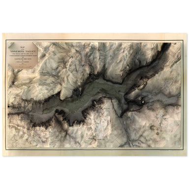
1865 map of the Yosemite Valley, California combined with a digitally-rendered 3-dimensional elevation. 2D print Lustre Prints: Archival photo ink...
View full details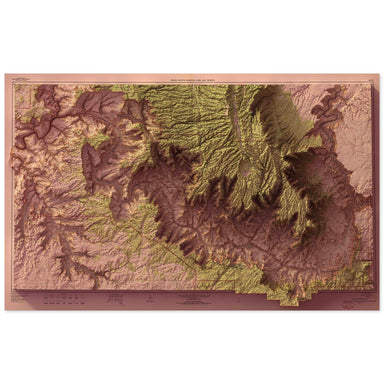
1962 United States Geological Survey topographic map of Grand Canyon National Park combined with a digitally-rendered 3-dimensional elevation. 2D ...
View full details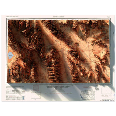
1956 Army Map Services topographic map of Death Valley, California combined with a digitally-rendered 3-dimensional elevation. 2D print Lustre Pri...
View full details

1904 United States Geological Survey topographic map of the Acadia National Park region combined with a digitally-rendered 3-dimensional elevation....
View full details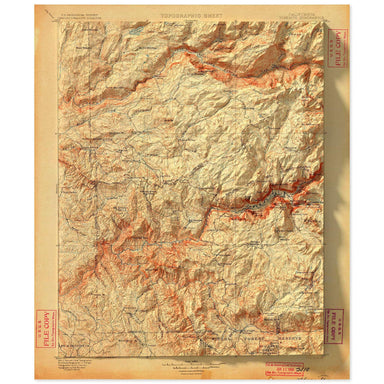
1900 United States Geological Survey topographic map of Yosemite National Parkcombined with a digitally-rendered 3-dimensional elevation. 2D print...
View full details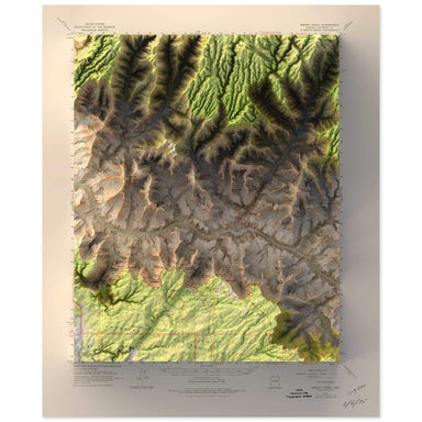
1962 United States Geological Survey topographic map of Bright Angel, Grand Canyon, Arizona combined with a digitally-rendered 3-dimensional elevat...
View full details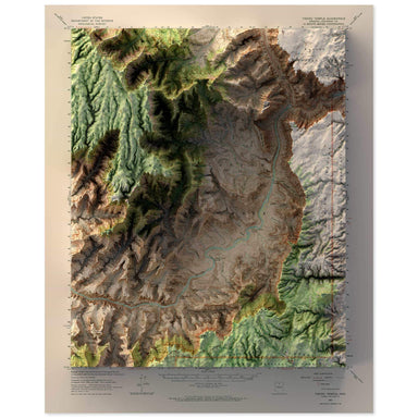
1962 United States Geological Survey topographic map of Vishnu Temple, Grand Canyon, Arizona combined with a digitally-rendered 3-dimensional eleva...
View full details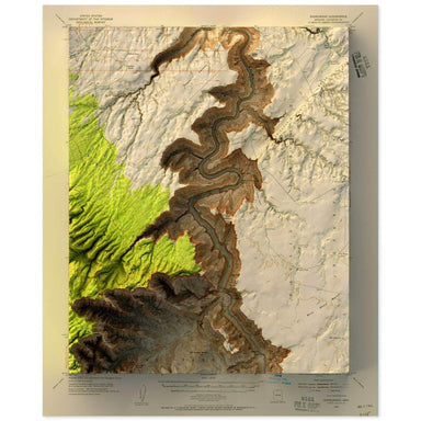
1954 United States Geological Survey topographic map of Nankoweap, Grand Canyon, Arizona combined with a digitally-rendered 3-dimensional elevation...
View full details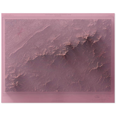
1949 United States Geological Survey topographic map of the Great Smoky Mountain National Park combined with a digitally-rendered 3-dimensional ele...
View full details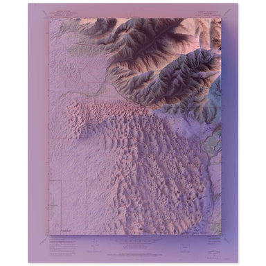
1967 United States Geological Survey map of Great Sand Dunes National Park combined with a digitally-rendered 3-dimensional elevation. 2D print Lu...
View full details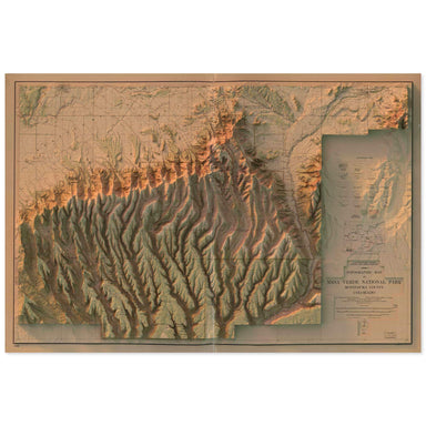
1915 United States Geological Survey topographic map of Mesa Verde National Park combined with a digitally-rendered 3-dimensional elevation. 2D pr...
View full details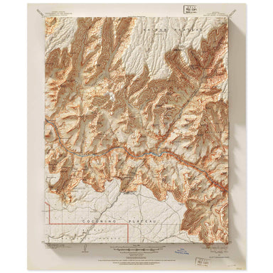
1903 United States Geological Survey topographic map of the Grand Canyon at Bright Angel Falls combined with a digitally-rendered 3-dimensional ele...
View full details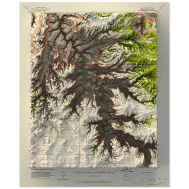
1962 United States Geological Survey topographic map of Supai, Grand Canyon, Arizona combined with a digitally-rendered 3-dimensional elevation. 2...
View full details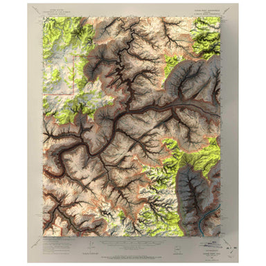
1962 United States Geological Survey topographic map of Kanab Point, Grand Canyon, Arizona combined with a digitally-rendered 3-dimensional elevati...
View full details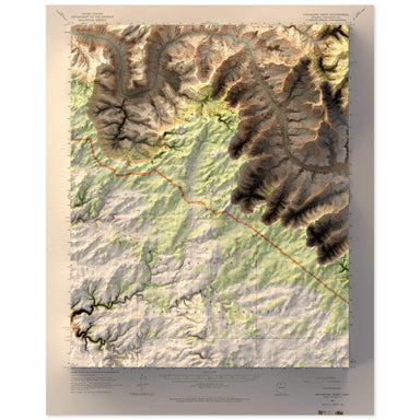
1962 United States Geological Survey topographic map of Havasupai Point, Grand Canyon, Arizona combined with a digitally-rendered 3-dimensional ele...
View full details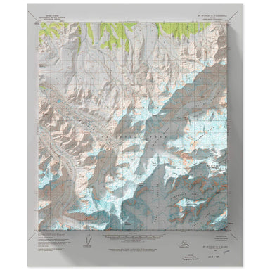
1954 United States Geological Survey map of Denali, Alaska combined with a digitally-rendered 3-dimensional elevation. 2D print Lustre Prints: Arc...
View full details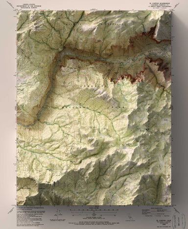
1990 USGS Map of Yosemite National Park combined with a digitally-rendered 3-dimensional elevation. 2D print Lustre Prints: Archival photo inkjet ...
View full details
1990 USGS Map of Yosemite National Park combined with a digitally-rendered 3-dimensional elevation. 2D print Lustre Prints: Archival photo inkjet ...
View full details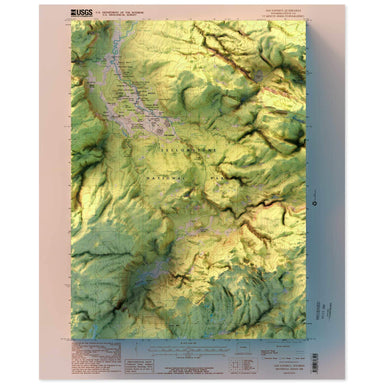
1986 United States Geological Survey topographic map of Old Faithful, Yellowstone National Park, Wyoming combined with a digitally-rendered 3-dimen...
View full details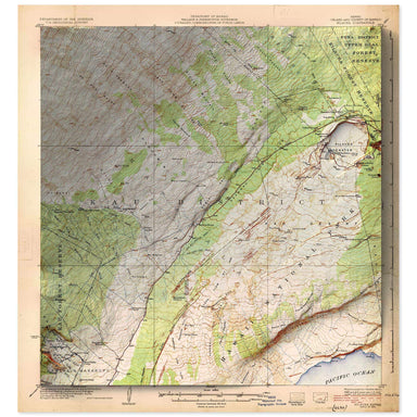
1924 United States Geological Survey topographic map of Kilauea, Hawaii combined with a digitally-rendered 3-dimensional elevation. 2D print Lustr...
View full details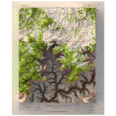
1962 United States Geological Survey topographic map of Tuckup Canyon, Grand Canyon, Arizona combined with a digitally-rendered 3-dimensional eleva...
View full details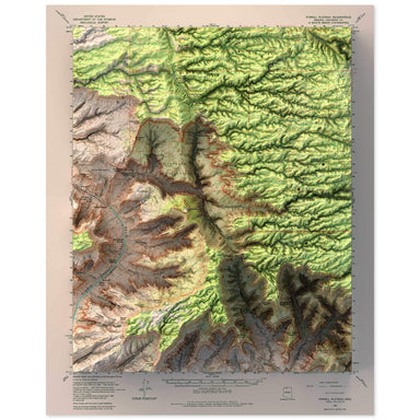
1962 United States Geological Survey topographic map of Powell Plateau, Grand Canyon, Arizona combined with a digitally-rendered 3-dimensional elev...
View full details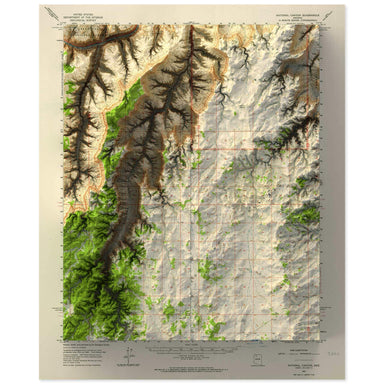
1962 United States Geological Survey topographic map of National Canyon, Grand Canyon, Arizona combined with a digitally-rendered 3-dimensional ele...
View full details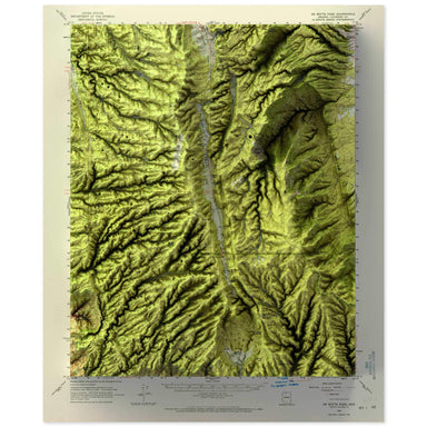
1962 United States Geological Survey topographic map of Demotte Park, Grand Canyon, Arizona combined with a digitally-rendered 3-dimensional elevat...
View full details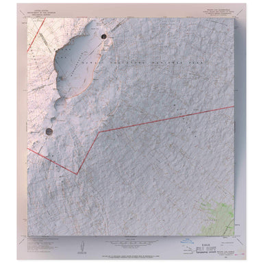
1966 United States Geological Survey topographic map of Mauna Loa and Hawaii Volcanoes National Park on the island of combined with a digitally-ren...
View full details